Accessible GIS Maps
Intelligent Minds
Smarter Decisions,
Better Earth
Current Version:
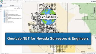
One map, all of Nevada & California
Geo-Lab.NET features thousands of GIS layers in one searchable map, with data sourced from hundreds of federal, state, and local agencies across California and Nevada.
Our goal is to help users explore a comprehensive overview of historical records, civic infrastructure, and population data for any location... all in one easy-to-use map interface.
Over 132,000 survey records in Nevada!
Geo-Lab.NET displays recorded surveys from Carson City, Churchill, Clark, Douglas, Elko, Eureka, Humboldt, Lander, Lincoln, Lyon, Mineral, Nye, Pershing, Storey, and Washoe counties.
We map these to location so you can quickly find the documents you need to approach your next project.
With features like Export to AutoCAD and countless GIS layers in one map, Geo-Lab.NET helps surveyors and engineers accelerate new drafting and simplify research.
One map, thousands of layers.
- Statewide tax parcels
- Recorded surveys
- Sewer and water
- Development permits
- FEMA flood hazards
- Census statistics
- Hydrography
- Easements
- Electrical infrastructure
- Geology and minerals
- Earthquake maps
- Hydrography
- Transportation data
- Zoning and land use
- EPA hazards
- USFS fire locations
- USGS surveys and soils
- MANY more...
Comprehensive Land Research
Whether you are prospecting real estate, planning a civic project, preparing for commercial development, or investigating regional land and property, Geo-Lab.NET makes it easy to find detailed information for any location in Nevada and California.